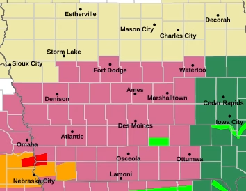
The National Weather Service in Des Moines is warning Iowans to prepare for multiple rounds of severe weather and heavy rainfall today, with the greatest threat expected across southern, central, and eastern portions of the state.
Forecasters say two rounds of thunderstorms are possible from this morning through approximately 5 p.m. The storms could bring damaging winds, large hail, and periods of heavy rain that may lead to localized flooding in some areas.


While some locations in eastern and southeastern Iowa could experience a brief break in the weather during the late morning or early afternoon, additional storms are expected to develop later in the day.
The National Weather Service is encouraging residents, emergency managers, and community partners to closely monitor forecasts and be prepared to take action if severe weather warnings are issued.
Officials urge Iowans to have multiple ways to receive weather alerts and to avoid driving through flooded roadways.
Additional weather information, including severe storm and flood outlooks, is available from the National Weather Service in Des Moines. Residents should stay alert for changing conditions throughout the day.