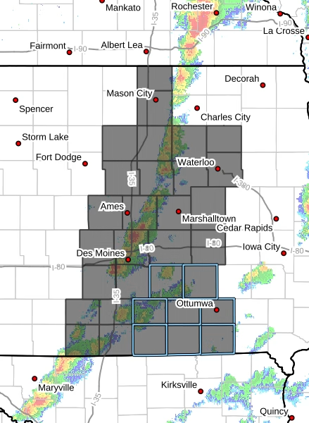
The National Weather Service has issued Tornado Watch 129, which remains in effect until 8 PM CDT this evening. This watch encompasses 32 counties across Iowa, primarily focusing on central, north central, northeast, south central, and southeast regions.
Counties Affected
Central Iowa:


- Boone
- Dallas
- Grundy
- Hamilton
- Hardin
- Jasper
- Marshall
- Polk
- Poweshiek
- Story
- Tama
North Central Iowa:
- Butler
- Cerro Gordo
- Franklin
- Worth
- Wright
Northeast Iowa:
- Black Hawk
- Bremer
South Central Iowa:
- Appanoose
- Clarke
- Decatur
- Lucas
- Madison
- Mahaska
- Marion
- Monroe
- Ringgold
- Union
- Warren
- Wayne
Southeast Iowa:
- Davis
- Wapello
Cities Included
This tornado watch includes major cities such as Des Moines, Waterloo, Marshalltown, and Mason City, as well as numerous smaller towns like Adel, Bloomfield, and Winterset. Residents in these areas should remain vigilant and prepare for severe weather conditions.
Primary Threats
The storm system poses several serious threats:
- Tornadoes: A few tornadoes are likely, with the possibility of a couple being intense.
- Hail: Widespread large hail is expected, with isolated events reaching up to 3.5 inches in diameter.
- Wind: Scattered damaging wind gusts could reach up to 70 mph.
Probability of Severe Weather
- Probability of 2 or more tornadoes: 60%
- Probability of 1 or more strong tornadoes (EF2-EF5): 40%
- Probability of 10 or more severe wind events: 70%
- Probability of 1 or more wind events >= 75 mph: 20%
- Probability of 10 or more severe hail events: 80%
- Probability of 1 or more hail events >= 2 inches: 60%
- Probability of 6 or more combined severe hail/wind events: >95%
- Mean storm motion is expected to be 40 mph to the east.