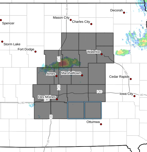
The National Weather Service has issued Tornado Watch, in effect until 10:00 PM CDT this evening, covering 19 counties across central, north central, northeast, and south central Iowa.
Counties Included in the Watch
Central Iowa:
Boone, Dallas, Grundy, Hamilton, Hardin, Jasper, Marshall, Polk, Poweshiek, Story, Tama


North Central Iowa:
Butler, Franklin
Northeast Iowa:
Black Hawk, Bremer
South Central Iowa:
Madison, Mahaska, Marion, Warren
Primary Threats
Forecasters warn that this is a particularly dangerous setup, with multiple severe hazards expected:
- Several tornadoes likely, including the potential for strong to intense tornadoes (EF2–EF5)
- Widespread large hail, with some stones reaching up to 4 inches in diameter
- Scattered damaging winds, with gusts up to 75 mph possible
Probability Highlights
- 80% chance of two or more tornadoes
- 60% chance of at least one strong tornado (EF2–EF5)
- 80% chance of large hail events (2 inches or greater)
- Greater than 95% chance of multiple severe hail and wind events combined
Storms are expected to move east at approximately 40 mph, increasing the urgency for residents to stay alert.
What Residents Should Do
Residents in the watch area should:
- Stay weather-aware and monitor updates throughout the evening
- Have multiple ways to receive warnings
- Be prepared to take shelter immediately if a warning is issued
This is a rapidly evolving severe weather situation. Conditions are favorable for significant storms, and residents are urged to take this watch seriously.