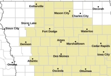
A band of accumulating snow will develop from west to east across parts of central and southern Iowa on Thursday morning. Snow will fall fairly heavily for a few hours at locations within this band, coinciding with the morning commute in many areas and increasing hazardous travel impacts. Please leave extra driving time Thursday morning as roads may become quickly snow covered with reduced visibility until the snow tapers off in the late morning to afternoon.
IAZ048-049-060>062-073>075-020445-
/O.NEW.KDMX.WW.Y.0001.250102T1200Z-250102T2100Z/
Story-Marshall-Polk-Jasper-Poweshiek-Warren-Marion-Mahaska-
Including the cities of Oskaloosa, Newton, Ames, Norwalk, Des
Moines, Grinnell, Pella, Knoxville, Marshalltown, Carlisle, and
Indianola
236 PM CST Wed Jan 1 2025


…WINTER WEATHER ADVISORY IN EFFECT FROM 6 AM TO 3 PM CST
THURSDAY…
* WHAT…Snow expected. Total snow accumulations between 2 and 4
inches.
* WHERE…Portions of central and south central Iowa.
* WHEN…From 6 AM to 3 PM CST Thursday.
* IMPACTS…Plan on slippery road conditions. The hazardous
conditions will impact the Thursday morning commute.
PRECAUTIONARY/PREPAREDNESS ACTIONS…
Slow down and use caution while traveling.
For the latest travel conditions, check the Iowa 511 app,
www.511ia.org, or dial 511.