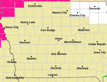
A Slight Risk (Level 2 of 5) for severe thunderstorms is in place for much of Iowa on Thursday, with hazardous weather conditions expected to develop and potentially continue into the overnight hours, especially across eastern portions of the state.
Forecasters are highlighting the main threats as damaging straight-line winds and isolated tornadoes. These storms could become strong enough at times to produce localized wind damage, including downed trees and power lines. In addition, there is a lower but still notable risk for large hail, particularly during the early stages of storm development.


Storm activity may begin late Thursday and persist into the night, increasing concern for areas in eastern Iowa where severe weather could continue after dark. Overnight storms are especially dangerous due to reduced visibility and the likelihood that people may be asleep when warnings are issued.
The outlook also notes that additional rounds of thunderstorms are possible later in the weekend into early next week, with the potential for further severe weather still being evaluated by forecasters. Residents are encouraged to stay weather-aware, have multiple ways to receive warnings, and be prepared to act quickly if severe weather develops.