


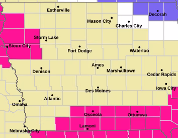
Dry air, gusty winds, and warm conditions are combining to create dangerous fire weather across portions of southern and northwestern Iowa today, especially between noon and 6 p.m.
Forecasters say winds will shift from the southwest to the west-northwest by midday and strengthen through the afternoon, reaching sustained speeds of 15 to 25 mph with gusts approaching or exceeding 30 mph at times. At the same time, relative humidity levels are expected to drop sharply. In southern Iowa — particularly in areas without recent snow cover — humidity could fall below 25 percent and even approach 20 percent in spots.


These conditions make it very easy for fires to start and spread quickly. Even a small spark could ignite dry grass or brush, and strong winds could push flames rapidly across open areas. Because of this heightened risk, a Red Flag Warning is in effect for parts of southern Iowa, and outdoor burning is strongly discouraged statewide.
Northwestern Iowa will also see elevated to near-critical fire danger, driven mainly by stronger wind gusts that may top 30 mph. Although humidity there may stay slightly higher, ranging from about 25 to 35 percent, the wind alone can still make fire control difficult.
The good news is that relief is expected soon. Cooler temperatures and increasing chances for precipitation are forecast this weekend and into next week, which should reduce fire danger and return conditions to safer levels.
Safety reminders:
- Avoid outdoor burning or activities that create sparks.
- Properly discard cigarettes.
- Secure trailer chains and equipment that could drag and spark.
- Follow all local burn restrictions.
https://www.weather.gov/media/dmx/DssPacket.pdf


")


